Catlin’s River Walk—a little bit of magic

My family and I were in the Catlins last week, in the southeast corner of the South Island. It’s a wild and remote area, home to more penguins and fur seals than humans. No urban adventures here—it’s a place for outdoor recreation.

One of the things we did was to hike part of the Catlins River Track (we didn’t have time to do the full track). It was unlike any other place I’ve been in New Zealand.

In fact, it reminded me most of eastern Pennsylvania, in spite of the fact that it shares not a single common species of plant or animal.

The track follows the Catlins River, a beautiful waterway that cuts through layers of limestone in one little cascade after another. Swing bridges cross the river several times, providing great aerial views of the water (and a little excitement for those who don’t like heights). The forest is old-growth beech which provides habitat for myriad native birds, carefully protected by intensive predator control. 

In addition to the beech, we were delighted to see two species of orchid on the forest floor, red-flowered mistletoes in the treetops, several species of slime mould, some lovely mushrooms, and a beautiful native harvestman. The birdlife was noisy and varied, but we weren’t lucky enough to see any endangered mohua. And, amazingly, there wasn’t a single sandfly! 

The whole effect was one of an enchanted forest. We were certainly enchanted.

The track is relatively flat—easy hiking for kids or those who can’t face the usual Kiwi hiking track going straight up a mountain, and because there’s no “goal” to reach, you can simply walk as far as you’d like, and then return. The entire length is 12 km one-way, with a return loop option through forestry land away from the river. 

I highly recommend this track. I’ll certainly be going back when I have enough time to do the whole thing.

Awesome Alpine Plants

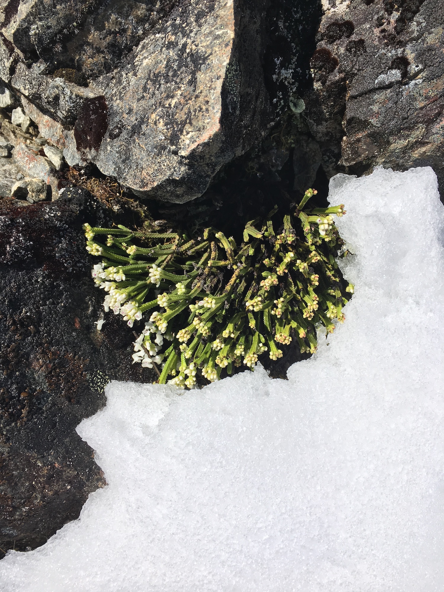
Whipcord hebe flowering in the snow

My daughter and I went for a hike on Saturday after being cooped up in the house all day Friday by a rip-roaring southerly storm. The storm lashed us with rain and hail, but in the mountains, it brought snow. Saturday morning, the beech forest at Cragieburn Forest Park was a winter wonderland.

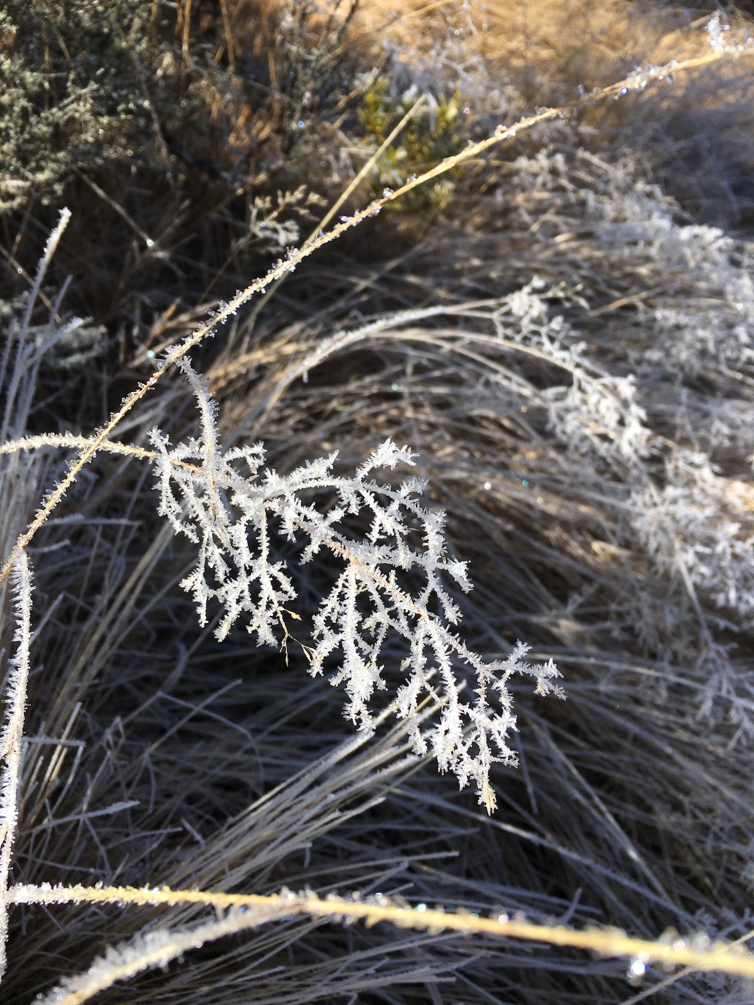
Climbing up out of the forest into the alpine areas, the intensity of the storm was clear—thigh-deep drifts filled the path in some places, while other areas had been blown clear down to the scree. Every tussock had a long train of sculpted snow on its leeward side, so you could almost feel the howling wind and the sting of blowing snow, in spite of it being a clear calm day.

Nestled among the rocks, we found this lovely whipcord hebe, flowering in spite of its slowly melting blanket of snow. And there were other plants peeking out of the snow, clinging to the scree.

Alpine plants are some of the toughest organisms around. They have to cope with intense sun, wide temperature fluctuations, drought, wind, and ice and snow. They have evolved a variety of adaptations in order to combat these dangers.

Short, cushion-shaped growth: A tight ball of branches and leaves resists damage and drying from fierce wind. The pinnacle of this growth form has to be plants in the genus Raoulia. Known as ‘vegetable sheep’, they form hard, tight masses of tightly packed leaves (akin to the texture of a head of cauliflower). Inside the mound, dead plant material builds up around the branches and acts like a sponge, soaking up rain when it’s available. Adventitious roots on the plant’s branches tap into this reservoir of water when the weather is dry.

Long roots: Unstable rocks and shifting scree make it difficult for alpine plants to stay put, and water is often far below the surface. To cope, they have long roots that anchor them deep into the rock. Some are also able to regrow from their roots if the top of the plant is snapped of by rockfall.

Drought-resistant leaves: Many alpine plants have leaves that are fuzzy on the underside, where the stomates (the breathing holes) are located. The hairs trap a layer of calm air against the leaf surface, slowing down water loss from the stomata. Other plants have narrow, vertically-oriented leaves that minimise exposure to the intense alpine sunshine, reducing evaporation.

Sunscreen: A waxy coating on many alpine plant leaves protects against intense sunlight and high temperatures.

Antifreeze: Ice crystals forming inside a living cell break the cell walls and kill it, so organisms living in cold environments have to somehow avoid freezing. Alpine plants protect themselves from freezing by manufacturing antifreeze from proteins in their tissues. The antifreeze prevents ice crystals from forming in the plant’s cells.

Energy conservation: The growing season in alpine areas is short, and nutrients are scarce. Many alpine plants respond by not reproducing every year. Instead of producing low-quality seeds that may not survive, they hoard resources until they have accumulated enough to reproduce successfully.

All these adaptations give most alpine plants a similar look—low, mounded, small-leaved and tough. But one plant in particular stands out as oddly showy and out of place.

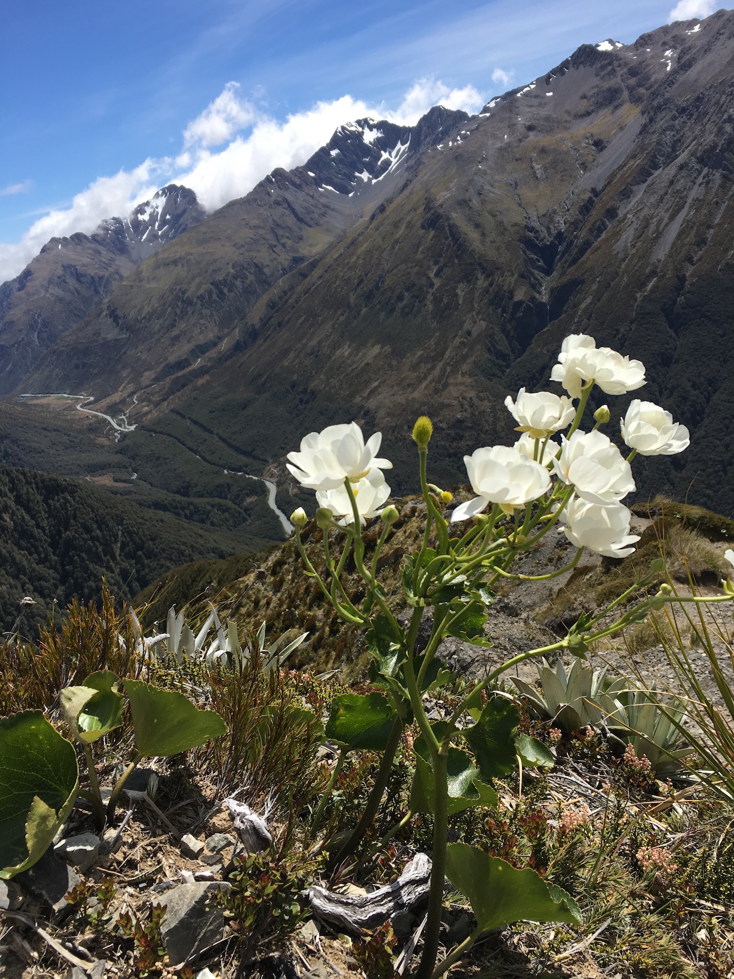
Mount Cook buttercup (Ranunculus lyallii)

The Mount Cook buttercup (aka Mount Cook lily), is an unusual alpine plant, in that it has big leaves and large, showy flowers. But even so, it is well-adapted to the alpine environment. Most plants have stomates on the underside of their leaves, because the underside is generally shaded and cooler, leading to less water loss. But in the alpine environment, sun-warmed rocks radiate heat, making the underside of the leaves warmer than the upper side on sunny days. The Mount Cook buttercup and its relatives have evolved stomates on the upper side of the leaves, in addition to the ones on the underside. The stomates on the top open when the underside of the leaf grows too warm.

Kaitorete Spit: An Overlooked Gem

Earlier this week, my daughter and I hiked onto the Banks Peninsula from Birdlings Flat. The walk afforded us gorgeous views of Kaitorete Spit.

Kaitorete Spit is only about 6000 years old, but is an important natural and cultural resource. Te Waihora / Lake Ellesmere, formed by the spit, is home to or visited by 166 species of birds and 43 species of fish which support commercial fisheries, recreational fishing and hunting, and traditional food gathering. In spite of its harsh, exposed environment, Kaitorete Spit is home to a remarkable number of threatened plants and animals, including pīngao (a native sand sedge prized for weaving), a flightless moth, and the katipo spider. A variety of lizards also flourish on the spit. The lake and spit have been important sources of food and fibre for Māori since they arrived in the area. Fragments of the oldest known Māori cloak were uncovered on the spit, dating to around 1500 AD, and many other signs of early Maori use of the spit have also been found there.

In pre-European times, Māori used the spit as a convenient highway as they travelled up and down the island. Unfortunately, the shifting gravel of the spit and the regular opening of the lake to the sea mean the spit isn’t passable in anything but the most capable of four-wheel drive vehicles. Today, travellers make the long trek all around the lake, so our home near the pointy end of the spit is a 40-minute drive from Birdlings Flat, just 25 km away on the fat end of the spit. But I’m happy to leave the spit to foot traffic—it helps protect the unique plants and animals that live there.

On a windy, wet day, Kaitorete Spit is a miserable, exposed place to be, but visit it on a warm sunny day, and you’ll see why it is an overlooked gem.

Ice and Fire

One of the things I like best about springtime here is the juxtaposition of hot and cold, especially in the high country. The sunshine is warm, but winter lingers in the shade. I’ve gone hiking in shorts and t-shirt through 15 cm of snow in past years.

This weekend, we didn’t make it up to snow, but there was spectacular frost on our little Saturday jaunt. Hiking up the shaded side of a hill, we were treated to glistening plants as the first rays of the sun hit thick frost.

In addition to the frost, we crunched over a lot of needle ice. Needle ice can occur when the soil temperature is above freezing, but the air temperature is below freezing. Liquid water rises through the soil via capillary action and freezes on contact with the air. As more water is drawn upward, the ice needles grow in length. They’re common in the high country in springtime, when warm sun heats the ground during the day, but the temperature drops quickly after dark.

Ice needles are more than just a curiosity. They’re a significant factor in soil erosion, because they often push soil upward along with the ice. This loosens the top layer of soil, making it prone to erosion by wind and water.

The air was cold on Saturday morning, and as we started up the hill, we were well-bundled. But like all good tracks in New Zealand, this one started off by going straight up. Between the climb and the sun, we were soon stripped to our t-shirts, enjoying the crunch of ice underfoot and the warmth of the sun overhead.

Hiking Under the Influence of Parenthood

My daughter and I went hiking for two days this week, taking advantage of the school holidays to get out. On our first day, we summited Little Mount Peel. Several years ago the whole family hiked the same track, though not to the top. In those days, my husband and I pulled the kids along behind us. Encouraging them on, waiting for them while they took breaks.

These days, it’s the other way around. I determined we would go at my pace, not the 14 year-old rock climber’s pace. She pulled me up the mountain, stopping occasionally to let me catch up. (Where did she learn that bland, patient smile, calculated to hide her boredom?)

I wish I could be as oblivious as the children I used to pull up the mountain.

Though I hiked behind her, I was still out in front, assessing risk, calculating her need for food and rest, figuring hiking times and return times, keeping an eye on her warmth. I was still the worrier, still the responsible parent.

When the kids were young, I dreamed of the day they could keep up. Now I fear the kids’ ability to get into trouble has outstripped their ability to manage risk. Not surprising. That’s what teens do.

But now I dream of a day when I can simply hike, without worrying about anyone’s safety but my own. I will go at my own pace, stop when I am tired, sit on rocky outcrops for hours contemplating the patterns of ridge lines in the distance. Perhaps once again I will experience a place fully, and not through the fog of parental responsibility.

Pigeon Bay Walkway

View from the head toward Christchurch.

Yesterday was a beautiful autumnal day. We headed out to the Banks Peninsula and did the Pigeon Bay Walkway.

It has been over a decade since we’ve been to Pigeon Bay. Last time we went, the kids were preschoolers. Then, we’d hoped for some sort of beach where the kids could play in the water, but Pigeon Bay is rocky. The shoreline is covered in cobble-sized rocks teeming with life. Lift any rock and a dozen crabs scuttle away. A decade ago, the pursuit of crabs delighted the kids. Still does. Yesterday, we also noted starfish, chitons, limpets and snails under the rocks.

But the main activity for yesterday was the walkway. It’s rated as a five hour return walk, but is mostly on a well-graded farm track. It’s easy going, and we did it in four hours, including a lunch break.

The track runs all the way to the head of the bay. It’s not exactly a wilderness experience—the land is a beef and sheep farm—but the views are spectacular. It’s one of the few places on the Banks Peninsula where you can get right out to the tip of the headland.

Out on the head, the cliffs are quite spectacular, and you can see the layers of volcanic deposits, well-spattered with poo from the shag colonies there. In the clear air yesterday, we could see all the way to the Kaikoura ranges.

The best part of the walk for me was looking down on a small pod of Hector’s dolphins feeding in the bay below. The dolphins were clearly circling and corralling fish, and there was a trio of gulls shadowing them in the air, picking off the fish the dolphins missed.

A lovely walk. Hard to believe it took us this long to get around to doing it.

Fungal Wonderland

A family hike on Saturday took us through a fungal wonderland on Mount Oxford. Everywhere we looked, it seemed, fruiting bodies were popping out. White, brown, blue, purple, red, black—fabulous diversity of species, form and colour.

My favourite of the day, however, were not the big, showy Amanita muscaria or the lurid purple Cortinarius porphyroideus, but these unassuming (and unidentifiable by us) little shelf fungi. They were growing out of the underside of a fallen log we had to duck under, and their gills made stunning, artistic patterns. Unremarkable though the mushrooms themselves were, the perspective of seeing them from below turned them into something truly special.

Amazing how a simple shift of perspective can turn the ordinary extraordinary.

The Square Trees and other natural wonders…sort of

The rock at Hanging Rock Bridge.

Years ago, when my husband and I were Peace Corps volunteers in the Republic of Panama, we visited the famous Arboles Quadratos (the Square Trees) in El Valle de Anton. The Arboles Quadratos were, according to the guidebooks, amazing freaks of nature—trees with perfectly square trunks. These remarkable plants grew in a special grove in the rainforest behind the hotel in El Valle, and were one of the town’s main tourist attractions.

So we went to see them.

They were buttressed trees, like many rainforest trees are. And the buttresses made them…sort of squarish, if you had a little imagination. I think there were, maybe, four of them in a cluster along the trail. Their beauty was completely overshadowed in my mind by the rest of the forest around them.

My daughter and I recently had a similar experience. On a road trip, we kept passing signs for Hanging Rock Bridge. It seemed all roads led to Hanging Rock Bridge. We figured it must be something pretty spectacular, if so many signs pointed the way to it.

So we went to see it.

And, yeah, there was an overhanging rock near the bridge. It was kind of cool. But the landscape around the bridge, with stunning limestone outcrops in every paddock, was far more spectacular than the bridge’s rock. If you’d gone out of your way to see the rock at Hanging Rock Bridge, you’d be disappointed.

Plenty of other ‘natural wonders’ fall short of the hype surrounding them. Others, unknown by anyone but locals, are truly stunning.

Like the Iglesia de Piedra, the Rock Church, near our village in Panama. This narrow chasm was carved by a small stream, and it’s one of the most incredible places I’ve ever been—maybe 30 metres deep, and so narrow you can touch both walls. Vegetation covers the opening high above, and makes everything look green below. The stream is shallow, and frogs hop away from every step. At the back of the chasm is a waterfall plunging all the way from the surface.

No tourists make pilgrimages to the Iglesia de Piedra. Few outside the surrounding area have ever heard of it. But it knocks the socks off many a popular tourist destination.

The world is full of these hidden gems, and one of the most wonderful things about living in different places is finding the local wonders. The beautiful places tourists never hear about.

I’ll still go to see the Square Trees and the Hanging Rock Bridges of the world, but much of the wonder of the world is reserved for those who live with it every day.

Volcanoes in the Mist

Our pre-Christmas family adventure this year took the form of a week on the North Island. One of the many things we did was to hike the Tongariro Crossing. The track climbs the slopes of Mt. Tongariro passes between Tongariro and Mt. Ngauruhoe. The volcanoes are active–the last eruption was in 1975, and they have a history of erupting about every nine years before that–so the landscape near the top is stark and raw, with sulphurous steam rising from fissures and craters, tumbled rock, and dark lava flows.

The area is tapu, sacred, to the local Māori, and it’s no surprise. Power and violence are written on the landscape, the lush lower slopes of the mountain only accentuating the devastation near the top. The awesome forces that shape the face of the planet are on display there. It is a place for gods to live.

Unfortunately, it has also become an incredibly popular tourist destination. The day we hiked it, there was a constant stream of shuttle buses arriving at the start of the track. We spent the day hiking on others’ heels, with hikers on our own heels. When we stopped for lunch, we counted sixty-eight people pass us in just 15 minutes. A quick back-of-the-envelope calculation, and we estimated that there were 1600 people on the track at the time.

It seemed to me that most of the people were treating the excursion as nothing but a physical challenge–a race to be completed or 19.4 km to tick off their to-do list. A large group of twenty-somethings all but pushed us off the track in their effort to pass us as they chatted loudly to one another, oblivious to the beauty around them. A group of teens playing loud music sauntered past. A man sat beside a crater lake doing a business deal on his cell phone.

I wanted to stop, to soak in the alien landscape, to feel the immense power of lava beneath my feet, to examine the crusted sulphur on the rocks and the tenacious plant life that colonised the harsh landscape. But like sheep being herded onto a truck, we were pushed along the narrow track by the people behind us. Fifteen seconds, thirty seconds was all we could snatch at a time to appreciate the landscape.

Like our favourite beach, the Tongariro Crossing has been diminished by its popularity. The gods are still there, in the steam and the lava, the raw craters blasted in the earth, but no one is paying attention.

Springtime Adventure–Mt. Oxford

I’ve been AWOL from the blog for a couple of days. I have a good excuse, though. Friday I raced from 5.30 am to 7 pm to do two days worth of work in one day. I managed to plant out all the peas, lettuce, and spinach, cleaned the house, baked cookies, did a bunch of writing and editing…

It was all in preparation for taking the entire day off yesterday to go for a hike.

We had a lovely day hiking to the top of Mt. Oxford. It was a long day, too, by any measure—7 1/2 hours of hiking, 31,700 steps (according to the phone’s health app), 20 km, and over 1 km elevation from carpark to peak.

Starting from a honey bee farm, the track climbs through beech forest and into subalpine tussock. Yesterday the hike had everything—snow, mud, sun and rain, wind. The lichens were especially exuberant, as was one particular rifleman (a tiny bird, for those of you unfamiliar with NZ fauna) who shot through the trees with such abandon, it smacked me in the face. It was the perfect springtime adventure.